.jpg)


CANADIAN AVIATION REGULATIONS
- CANADIAN AVIATION REGULATIONS
- Airports
- The Circuit
- Airspace Classification
- VHF and LF Airways
- Control Zones
- VFR Weather Minima
- Special VFR
- VFR Over-the Top
- Cruising Altitudes
- Altimeter Rules
- VFR Flight Plans
- NOTAMs
- National Security
- Emergency Location Transmitters (ELT)
- Priority Radio Communications
- Transponder Requirements
- Fuel Requirements
- Passenger Briefings
- Pilot Privilege
- Wake Turbulence
- Jet Blast Hazard
- Seat Requirements
- Oxygen
- Documents on Board Aircraft
- Aircraft Equipment Requirements
- Aircraft Icing
- Minimum Altitude
- Rules of the Air
- References
This section is designed to prepare students for Transport Canada as PSTAR examination, which is required by student pilots before they can complete their first solo flight. While this section focuses on the Canadian Aviation Regulations, it also includes reference to flight operation procedures and requirements, as well as human factor elements, that are included in the Study Guide for the PSTAR examination.
Airports
Two types of airports exist in Canada: an aerodrome: which is “any area of land or water designed for arrival, departure, and movement of aircraft,” and an airport, which is an aerodrome that is certified by Transport Canada for either public or private use.
The pilot of an aircraft must report the aircraft’s landing to the operator of the airport (or the operator’s representative), listed in the Canada Flight Supplement.1 Incidentally, the Canada Flight Supplement is essentially a directory of all published airports in Canada and describes the physically layout of runways and taxiways, radio frequencies, etc.—information that is crucial for the pilot to refer to when flying to an airport or aerodrome. (Unless otherwise indicated, reference in this manual to “airports” will generically imply both certified airports and non-certified aerodromes.)
Futher Readings:
Airport References from Canada Flight Supplement
Runways and Taxiways
As is indicated in the diagram above, runways are numbered in accordance with magnetic track in Southern Domestic Airspace (as opposed to true track in the Northern Domestic Airspace2), the number is rounded to the nearest 10° increment and the third digit is dropped (340° equals 34).
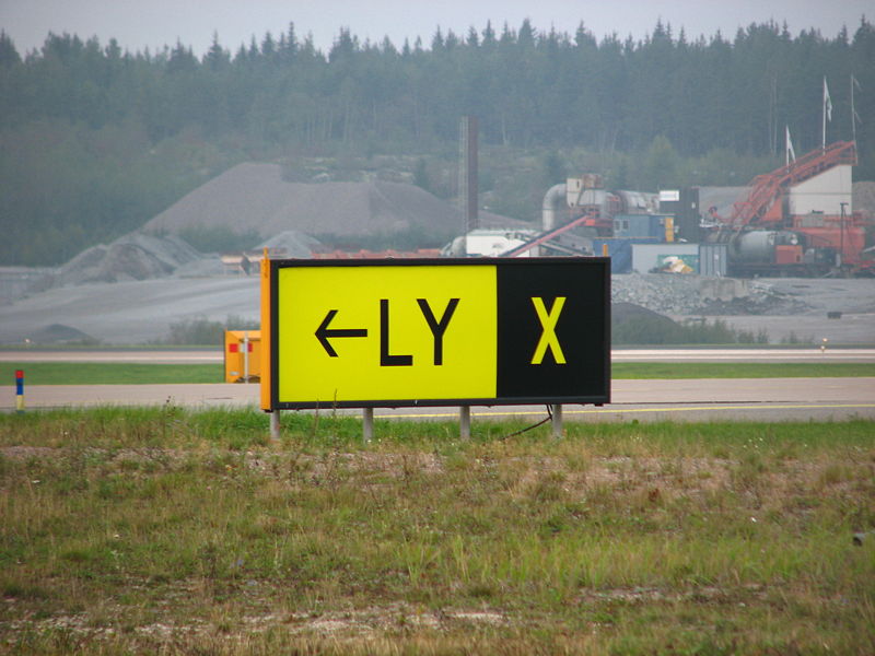
Taxiways are lettered (Alpha for A, Bravo for B, etc.). Aprons (aircraft loading and servicing areas) are numbered. Yellow lines track the centre of taxiways, and broad double yellow lines (one solid, and one dashed) indicate the “hold-short” positions.
A closed runway or taxiway is indicated by a white or yellow “X” that is 20 ft. in length.
Where a runway at an airport does not have a prepared landing surface, the takeoff and landing area will be delineated by international orange and white markers; at an aerodrome, the same area will be shown by international orange markers (no white).
The minimum runway lighting required for night operations at an airport is two parallel lines of fixed white lights visible for two miles and which marks the landing and takeoff areas. Some registered aerodromes are approved to use retro-reflective markers instead of runway lights.
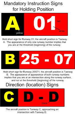
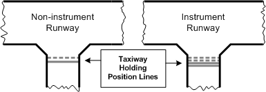
Mandatory Instruction Signs are signs located where a taxiway leads onto a runway and instructs the pilot to hold short and clear the runway; these signs are indicated by white letters, numbers, or symbols against a red background. Where aircraft movements are supervised by a Control Tower, Mandatory Instruction Signs required that a clearance be received by the pilot before proceeding further; where aircraft movements on a runaway are not controlled by a control tower, the pilot can only proceed beyond a Mandatory Instruction Sign if he or she has determined it safe to do so.
Direction (location) Signs do not display the colour red, but are based on either a black or yellow background, and give the present location of the aircraft (black background), and the approaching taxiway (yellow background).
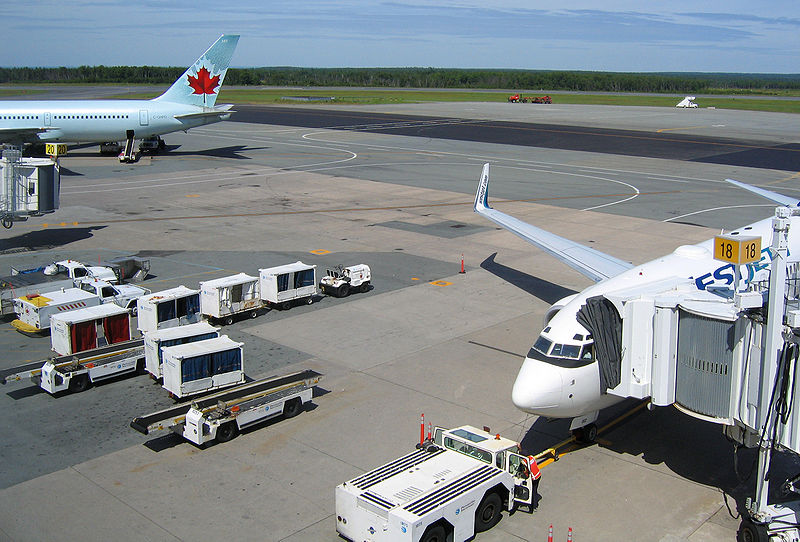
The Manoeuvring Area of an airport or aerodrome refers to the areas used for the taking off and landing, as well as taxiing of aircraft, but excludes the aprons. Aprons denote areas were passengers and cargo are loaded and unloaded, and where aircraft are serviced or parked.3
It is prohibited for persons to walk, stand, drive or park any vehicle, or cause any obstruction of aircraft movement at an airport without permission from a control tower or from the operator of the airport where a control tower does not exist. Additionally, no person may allow any animal in their care to run at large within the boundaries of an airport.
Windsocks indicate wind direction and speeds. The sock is horizontal for winds greater than 15 KTS (KT), 5° below horizontal for 10 KT, and 30° below for 6 KT.
The Circuit
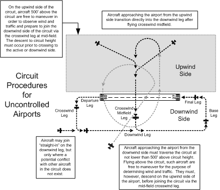
Traffic circuits (referred to as “traffic patterns” in the US) are standard patterns located 1000’ AGL (above ground level) flown by aircraft for the purposes of landing and taking off. They are composed of two sides: downwind and upwind. In a standard circuit, the downwind side is the active side, while the upwind side is the non-active or “dead” side. The active side is comprised of four “legs”: crosswind leg, downwind leg, base leg, and final leg. A fifth leg commonly referred to is the crosswind midfield leg.
Uncontrolled Airports
Uncontrolled airports lack Air Traffic Control (ATC); instead, pilots broadcast their positions on a UNICOM VHF frequency.4 We refer to such airports as ATF airports—Aerodrome Traffic Frequency.
When departing from an uncontrolled airport, pilots broadcast prior to moving onto a runway, when commencing takeoff roll, and when clear of the circuit.
When arriving, they report their position (including altitude), intentions, and ETA when 5 minutes from the airport area; they report when joining the circuit, when established on final approach, and when clear of the runway after landing.
Pilots flying continuous circuits report midway point on the downwind leg, when on final, and when clear of the runway after landing.
NORDO (no radio) aircraft operate freely at uncontrolled airports.
To reduce the risk of traffic conflict, the rules for joining the circuit are restrictive. At ATF airports pilots must position themselves on the upwind side of the active runway (runway in-use) and cross over to the downwind side at circuit altitude. Crossing over the runway in this manner, the track of the aircraft is essentially perpendicular to the downwind leg. When the pilot has sufficient distance from the runway to provide room to manoeuvre the aircraft, a left turn or right turn (depending on the direction of the published circuit) is made to enter the downwind leg at the abeam the mid-point of the runway. A pilot may also join straight-in on the downwind leg (at circuit altitude), but only if this does not create a hazard to other aircraft. Whenever joining the circuit, the pilot should report over the radio if able when turning on to the downwind leg.
Mandatory Frequency Airports
Busy uncontrolled airports have mandatory frequencies (MF), as published or indicated in the Canada Flight Supplement.
Typically MF airports are those which are busier than ATF airports, but not busy enough to warrant a control tower. They are also typically found at airports with frequently used “instrument approaches,” where pilots use navigation equipment to make an approach for landing while still in the clouds (without visual reference to the ground).
At an MF airport, position reporting by pilots over a prescribed VHF frequency is mandatory, and all pilots must maintain a listening watch.
MF airports are commonly associated with Flight Service Stations (FSS), which provide air traffic services, but they can also be uncontrolled airports that lack an FSS. A FSS unit is composed of NavCanada staff (the agency which administers air traffic control in Canada) that are trained to “co-ordinate” air traffic by relaying information to inbound and outbound air traffic.
FSS units are referred to using the designator “Radio”—for example, the FSS unit which operates at Nanaimo Airport is referred to as “Nanaimo Radio.”
Importantly, a FSS unit does not issue clearances to aircraft as a control tower does; instead, FSS simply provides an advisory service to pilots whereby pilots must keep FSS staff advised of their intentions and aircraft positions and movements.
There are two types of MF airports, the first is referred to as simply an MF airport, and the second is referred to as an MF Area airport (MFA). MFA airports are essentially ATF airports where position reporting and radio monitoring is required; the rules for joining the circuit are identical to those for an ATF airport. At an MF airport (not an MFA airport), there is a ground station through whom radio broadcasts are directed, and the rules for joining the circuit are more flexible to facilitate aircraft manoeuvring for landing after performing an instrument approach—pilots may join the circuit straight-in on the final or base legs, at a 45° angle to the downwind leg, or in addition to the procedures prescribed for ATF airports. The ground station commonly relays traffic and wind information to inbound aircraft. At an MFA airport, in contrast, there is no ground station, and radio communications are identical to ATF airports.5
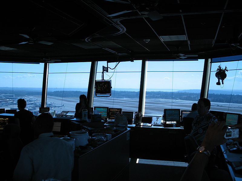
Controlled Airports
Controlled airports are surrounded by control zones which are controlled by an Air Traffic Control Unit (ATCU), usually a control tower (control zones are discussed below). However, some control zones, such as those which surround Nanaimo and Kamloops Airports, are administered by FSS where MF rules are in effect. As a rule, control zones with control towers are considered to be Class C or D Control Zones, while control zones with FSS using MF rules are considered Class E Control Zones (classifications are discussed later in this chapter).
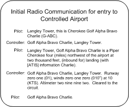
Prior to entering the control zone a pilot must contact the ATCU, usually a control tower, report his aircraft type, position and intentions. The pilot is then normally provided with a clearance. While in the control zone he must maintain a listening watch.
The tower controller may provide specific clearances, or he may say “cleared to the circuit” whereby the pilot is expected to join the downwind leg at circuit height.
Controlled airports have ATIS broadcasting frequencies (Automatic Terminal Information Service) which are monitored by pilots prior to entry.6
NORDO traffic is restricted from entering control zones unless they receive special permission.
When NORDO flights are permitted, or in case of communication failures, ATC uses a light gun to communicate clearances, the interpretation of which is indicated in the table (right).
Light communications are acknowledged by the pilot by rocking the wings (day) or a single flash of the landing light (night).
|
SIGNAL |
GROUND AIRCRAFT |
AIR AIRCRAFT |
|---|---|---|
|
Flashing Green |
Cleared to taxi |
Return to land |
|
Steady Green |
Cleared to takeoff |
Cleared to land |
|
Flashing Red |
Taxi clear of runway |
Airport unsafe |
|
Steady Red |
Stop |
Do not land; continue circling. |
|
Flashing White |
Return to starting point |
— |
|
Blinking Runway Lights |
Vacate runway immediately |
— |
|
Red Pyrotechnical |
— |
Do not land for the time being |
Clearances and Instructions
While in controlled airspace where ATC has authority for the operation of aircraft, controllers can issue two types of directives: a clearance, and an instruction. When a pilot has received and accepts a clearance, the clearance must be complied with, unless the pilot feels it unacceptable for reasons of operational safety. If the pilot feels it is unacceptable, he or she must immediately inform ATC of this fact.
Acknowledgement of a clearance by a pilot is viewed by ATC as the pilot’s acceptance.
In contrast, an ATC instruction requires that a pilot comply unless aircraft safety is jeopardized.
An ATC clearance will be identified by the word “clear” somewhere in its contents. An ATC instruction will be readily identified, but need not include the word “instruct.”
IMPORTANT: Complying with a clearance or instruction does not relieve the pilot from any responsibilities for maximum flight safety and good Airpersonship (including obstruction clearance and distance from cloud or other aircraft).
Airspace Classification
The geographic classification of Canadian Airspace is specified in the Designated Airspace Handbook, something that is rarely seen in pilot bags, but which is available should detailed reference to airspace dimensions be required.
Northern and Southern Domestic Airspace
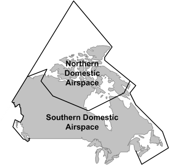
Canadian Airspace is divided into two fundamental areas: Northern Domestic Airspace (NDA) and Southern Domestic Airspace (SDA). The division has a few important rules: While the proper cruising altitude in the SDA is based on magnetic track, cruising altitude in the NDA is based on true track (discussed below). Additionally, runway headings are also based on magnetic track in the SDA, while true track is used in the NDA. Finally, rules for altimeter settings are also based on the SDA/NDA division (also discussed below). Generally, NDA consists of airspace located north of Inuvik, Yellowknife, Churchill, Ivujvik and Iqaluit.
Canadian Airspace is further divided into seven classes, each providing individual rules of access, flight regulations, and Air Traffic Control (ATC) responsibility.
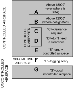
IMPORTANT: Do not confuse the seven classes with rules of weather minimum regulations that are quite different. Weather minima are established based on the fundamental difference between controlled and uncontrolled; for practical purposes, of the seven classes, only Class G is uncontrolled airspace.
The characteristic of the seven classes may be summarized as follows:
Class A
- All airspace from 18000’ to Flight Level (FL) 600 (60,000’).
- Controlled airspace (referred to as High Level Controlled Airspace) whereby all aircraft must have a clearance.
- Only IFR flight is permitted.
- Altimeters are set to 29.92” Hg. (Standard Pressure).
Class B
- All low-level controlled airspace from above 12500’ up to, but not including, 18000’.
- Controlled airspace (referred to as Low Level Controlled Airspace) whereby aircraft must have a clearance.
- Only IFR and Controlled VFR flight is permitted.
- Altimeters are set to local pressure settings.
- Transponders are required with Mode C (altitude encoding) capability.
- Altimeter must have been tested within last 24 months.
- Adequate navigation equipment required for flight planned route.
Class C
- Specifically defined airspace around designated airports described as terminal control areas and associated control zones.
- Controlled airspace whereby both IFR and VFR are permitted but where VFR flights cannot enter until they receive a clearance from ATC.
- ATC provides traffic separation to IFR flights, while VFR receive traffic information (and conflict resolution upon request).
- The Pilot-in-command has the responsibility to avoid other aircraft, maintain terrain and obstruction clearance, and remain in VFR weather.
- NOTE: a pilot must communicate to ATC any concerns related to pilot responsibilities.
- While operating in Class C, aircraft must be equipped for two-way radio communication, and must maintain a continuous listening watch.
- Transponders are required with Mode C (altitude encoding) capability.
- Class C airspace reverts to Class E status when ATC services are not operating. When the Control tower is closed at Langley Airport, for example, the communication used by pilots in the control zones reverts to ATF/MF (MFA) rules and procedures, where pilots direct radio communciations to “Langley Traffic.” At other airports—Prince George or Abbotsford airports, for example—remote FSS units provide MF ground services. In the case of Abbotsford Airport, pilots communicate remotely with Cranbrook Radio, while in the case of Prince George, pilots communicate with Williams Lake Radio.
Class D
- Specifically defined airspace around designated airports described as terminal control areas and associated control zones.
- Controlled airspace whereby both IFR and VFR are permitted, but where VFR flight must establish two-way communication with an appropriate ATC authority prior to entry.
- IFR flights are provided with separation, while traffic information is provided to VFR flights.
- While operating in Class D, aircraft must be equipped for two-way radio communication, and must maintain a continuous listening watch.
Class E
- Specifically defined airspace normally associated with airways, control area extensions, and transition areas, including designated airports without an operating control tower.
- Controlled airspace in which both IFR and VFR flight may operate; separation is provided to IFR flights, but there are no special requirements for VFR flights.
Class F
- Airspace in which special activities take place, which may or may not restrict air traffic.
- Class F airspace is specifically described in VFR Navigation Charts (VNCs), as well as a publication entitled Designated Airspace Handbook (Transport Canada).
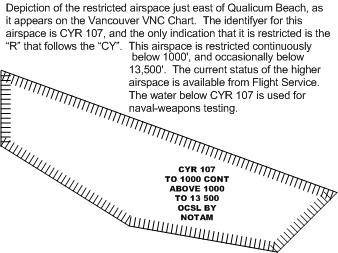
- The type of Class F airspace is indicated in the identifier published in charts, of which the following is a typical example: CYA123(T). “CY” indicates that the airspace is in Canada. The third letter, in this case “A,” indicates the type of airspace; there are three types—”R” meaning “restricted” and “D” meaning “danger,” both of which cannot be entered as specified on the chart (“D” only appears in relation to restricted airspace in international waters), and “A” meaning “advisory,” which can be entered. Class F areas designated CYA are associated with special flight activity and caution should be used. The type of activity is indicated by the letter in parentheses “(T)” where “T” indicates flight training. Others are acrobatics (A), test flight areas (F), military training (M), hang gliding (H), parachuting (P), and soaring by gliders (S).
- Unless otherwise specified, the radio frequency 126.7 MHz. should be monitored in Class F areas.
- Class F restricted areas (CYR) may be created by Notices to Airmen (NOTAMs) and may therefore not appear on charts.
Further Readings: Transport Canada's Restricted Area — What Restricted Area?
Class G
- Airspace not designated A, B, C, D or F, within which ATC has no authority or responsibility.
- Uncontrolled airspace for both IFR and VFR traffic.
- IMPORTANT: Unless, controlled airspace is specified on a chart, Class G uncontrolled airspace extends up to, but not including, 18000’.
VHF and LF Airways
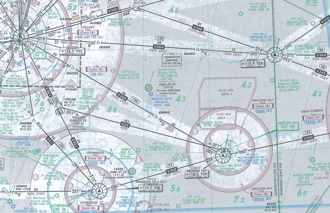
Airways are the highways in the sky and interconnect major airports using centerlines established by radio navigation aids, traditionally ground-based, but now sky-based, through the use of satellite transmitters (GNSS). Airway sare commonly used by private pilots during cross-country flights, but most commercial air traffic is restricted to on airway flying especially commercial flights conducted at the lower levels. importantly, most of this commercial traffic is flown using IFR rules (Instrument Flight Rules), where air traffic controllers are responsible for the separation of aircraft. The above depiction is a section of Jeppesen IFR enroute chart which depicts the airways as they existed at the time to the southeast of Calgary; note that there is limited geographic data on the chart as its primary fuction is to provide data for radio-based navigation. Central to IFR operations is the assumption that aircraft are operating in cloud condition and pilots cannot therefore provide visual separation amongst themselves. Separation of aircraft is provided by the air traffic controller. The airspace dimensions surrounding airways, which is always controlled airspace, and often restricted, must be known by private pilots for the purpose of avoidance. Private pilots can only enter the airspace surrounding an airway when conditions are the VFR, and are restricted from airway airspace when the weather is below VFR minimum conditions. Student pilots must therefore learn how to map out the boundaries of these airways.
Class E airspace between VHF Omni Range (VOR) transmitters and LF/MF (Non-Directional Beacon or NDB) transmitters form airways.
Airways have specified dimensions indicated on charts; they are always controlled airspace and therefore specified weather minima apply to VFR flight.
At or above 12500’ (i.e., up to 18000’) airways are automatically defined as Class B airspace, and therefore the requirements of Class B apply.
Where airways penetrate designated airports surrounded by Class C or D airspace, as indicated on charts, the respective rules of Class C or D airspace also apply.
Unless otherwise indicated on charts, airways are automatically based at 2200’ AGL.
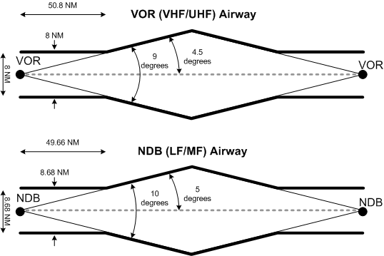
Airways between VORs are referred to as Victor Airways (V21 for example). They have a minimum width of 4 NM on either side of the VOR, which expands by 4.5° from the centre line.
Airways between NDBs have the same base and ceiling, but their minimum width is 4.34 either side of the beacon, and expands at the rate of 5° from the centre line. The special weather minima for airways are described below (see other controlled airspace).
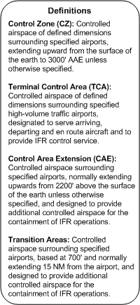
Control Zones
Control Zones surround specified airports indicated on charts. They usually have a 7 NM (nautical mile) radius and extend from the surface to 3000’ AAE (above aerodrome elevation).
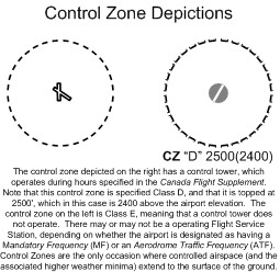
They may be designated Class B, C, D or E airspace. Class B, C, and D Control Zones have control towers, while Class E control zones do not. Control zones are the only instance where control airspace—as well as the associated higher weather minima described below—extend to the surface. The purpose of control zones is to restrict VFR aircraft from operating in the vicinity of the airport when IFR traffic is making instrument approaches in conditions of low ceilings and poor visibility.
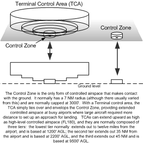
Control Zones associated with larger airports are commonly surrounded by Terminal Control Areas, Transition Areas, or Control Area Extensions, shown on charts. This expanded controlled airspace is designed to provide separation between aircraft in high-density traffic areas or separation between IFR and VFR traffic. Large transport aircraft, for example, will require more than 7 NM to descend for landing. At Vancouver International Airport there is a 7 NM Control Zone; but surrounding the Control Zone is 45 NM radius Terminal Control Area (TCA) which has the dimensions of an inverted “wedding cake”; as you get closer to the Control Zone, the floor of the TCA gets closer to the ground in accordance with numerous “step down” sectors. The rules of the Vancouver Control Zone (Class C Airspace) are the same as the Vancouver TCA—a clearance from ATC is required prior to entry, Mode C Transponder, etc. While TCAs are either Class C or B (normally Class C), Control Area Extensions and Transition Areas are a lower grade of expanded controlled airspace; a clearance is not required to enter Control Area Extensions or Transition Areas, but higher weather minimum are required when flying in these areas.
VFR Weather Minima
|
AIRSPACE |
FLIGHT VISIBILITY |
DISTANCE FROM CLOUD |
DISTANCE ABOVE GROUND |
|---|---|---|---|
|
Control Zones & Aerodrome Traffic Zones |
3 miles minimum |
1 mile horizontal & 500’ vertical |
500’ vertical |
|
Other Controlled |
3 miles minimum |
1 mile horizontal & 500’ vertical |
— |
|
Uncontrolled at or above 1000’ AGL |
1 mile minimum during day |
2000’ horizontal & 500’ vertical |
— |
|
3 miles minimum during night |
|||
|
Uncontrolled below 1000’ AGL |
2 mile minimum during day |
clear of cloud |
— |
|
3 miles during night |
Flight in all airspace is restricted to conditions above established weather minima—distance from existing clouds and flight visibility. Pilots must know the minima.
As discussed above, there are two rules—weather minima for controlled airspace, and minima for uncontrolled airspace. Within controlled airspace, a further distinction is made for flight within Control Zones, and, within uncontrolled airspace, a further distinction is made for flight at or above 1000’ AGL and flight below 1000’ AGL.
Accordingly, VFR weather minimum varies with the following airspace categories, described in the table (above).
Special VFR
When the weather in control zones (described above) is below VFR conditions (3 miles visibility and a 1000’ ceiling), VFR pilots can still conduct arrivals and departures, but only if they receive what is referred to as a special VFR clearance.
Special VFR is never offered—it must be requested by the pilot. The request is normally provided, except when the VFR aircraft may be in conflict with IFR aircraft. The minimum for Special VFR is 1-mile flight and ground visibility (when reported). At night Special VFR will only be authorized for the purpose of landing at a destination airport.
VFR Over-the Top
This requires the pilot to be VFR-OTT rated and the weather minima are based on both the destination airport and the “cruise” portion of the flight.
VFR-OTT is only permitted during the day.
At all times the aircraft must be operated at least 1000’ vertical distance from cloud, and the flight visibility must be at least five miles.
When operating between two layers, those layers must be at least 5000’ apart.
On the basis of a Terminal Aerodrome Forecast (TAF) or a Geographic Area Forecast (GFA),7 the weather at the destination airport must be scattered or clear, with no forecast of precipitation, fog, thunderstorms, or blowing snow; where a TAF is used, these conditions must be forecast for a period no less than 1 hour before and 2 hours after the ETA; where an FA is used, these conditions must be forecast no less than 1 hour before and 3 hours after the ETA.8
Cruising Altitudes
When flying the Southern Domestic Airspace above 3000’ AGL, VFR flights flying west-bound (magnetic track of 180° to 359°) must fly at even 1000’ altitudes plus 500’; when flying east-bound (magnetic track of 360° to 179°) VFR flights must fly at odd 1000’ altitudes plus 500’. Remember that true tracks are used in the Northern Domestic Airspace.
Altimeter Rules
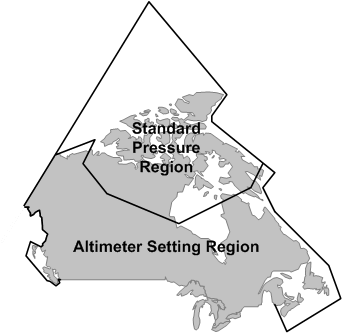
The rules for altimeter use vary between the Southern Domestic Airspace and the Northern Domestic Airspace (see P. 62). The Southern Domestic Airspace is referred to as the Altimeter Setting Region, and in this region the altimeter must be continually set to the nearest reported altimeter setting. Before takeoff, the altimeter must be set to the airport reported setting, or, if not available, the airport elevation. During flight, it must be set to the setting of the nearest reporting station (FSS or control tower). Prior to landing, it must be set to the destination airport if available.
Northern Domestic Airspace is referred to as the Standard Pressure Region, where it is required that the Altimeter be set to 29.92”Hg—known as standard pressure. The exception to this is prior to descent for landing and before taking off, when the airport setting, if available, or elevation is required. When standard pressure is used by the pilot, he must refer to his altitude as “flight level” where, for example, 5,500’ is Flight Level 55 (FL055).
VFR Flight Plans
A flight plan must be filed with Air Traffic Services (ATS) for every flight except when:
- the flight is conducted within 25 nautical miles of the airport or departure or;
- a flight itinerary is filed with ATS or a responsible person
A Flight Plan (see copy, P. 208) must be closed by way of filing an Arrival Report with ATS no later than the Search and Rescue Action Initiation Time (SRAIT) specified in the flight plan, or, in the event an SRAIT was not specified by the pilot, no later than 60 minutes after last reported estimated time of arrival (ETA). After these times search and rescue action is started.
Flight Itineraries can be used instead of Flight Plans. The Flight Itinerary can be filed with ATS or left with a “responsible person”—i.e., any person who agrees to notify ATS if the aircraft does not arrive within the required time limits. Where a Flight Itinerary is used, the pilot must report his or her arrival prior to the SRAIT (where an SRAIT has been specified) or within 24 hours of the last reported ETA. The SRAIT or 24 hours is also the time at which the responsible person must report the overdue status to ATS. The content of a Flight Itinerary is identical to the content of a Flight Plan. Note that the responsible person must be advised how to advise ATS of overdue status.
NOTAMs
NOTAMS—which stands for Notices to Airpersons—are notices issued to pilots concerning the establishment, condition or change in any aeronautical facility, service, procedure or hazard. The system of NOTAM distribution is designed to be timely, and it is accessed by pilots through personnel employed at Flight Service Station (FSS). Normally, NOTAM information is provided to pilots when they obtain a weather briefing from FSS. The idea is that a pilot who obtains a pre-flight briefing that includes NOTAMS will be informed of all up-to-the-minute information related to the flight.
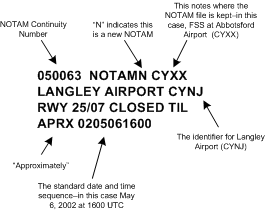
When pilots obtain NOTAMs from FSS, they are interpreted and summarized by the FSS Specialist. If you are required to read NOTAM text (which is quite rare), it is important that you understand the validity times. In the example presented above, the NOTAM—which informs pilots of the closure of the grass runway at Langley Airport (CYNJ)—has a continuity number (the first two numbers in this sequence being the year of issue, and the remaining numbers being the number sequence within that year). The grass runway is scheduled to be closed until approximately 1600 UTC on May 6th.

Because the expression “approximately” has been used, it is required that a cancelling NOTAM be issued before the runway is re-opened.
National Security
Air Defence Identification Zones, or ADIZ, are established in the coastal regions of Canada.9 A Flight Plan or Flight Itinerary must be filed with ATS for any flight in an ADIZ (there is facility for “air filing” where ground communication is not possible at the departure airport).
For VFR flights the Flight Plan or Flight Itinerary must indicate the estimated time and point of entry into the ADIZ. If there is a change in the routing or ETA of ADIZ penetration, ATS must be advised.
Specifically, the pilot must advise ATS if the aircraft is not expected to arrive within plus or minus five minutes of any specified reporting point, point of ADIZ entry, or destination with the ADIZ.
ATS must be similarly advised if the aircraft is not within 20 NM of the planned point of ADIZ entry, or the planned routing centre line.
Also, within an ADIZ or other Canadian Domestic Airspace, pilots must be aware of security state referred to as ESCAT, which means Emergency Security Control of Air Traffic Plan. When ESCAT is established, all takeoffs must have prior approval from ATS and pilots must land when required to do so by ATS.10 ESCAT procedures are tested from time to time by way of a radio broadcast and will not disrupt normal flight other than the requirement to provide an acknowledgement to the test message.
Emergency Location Transmitters (ELT)
All aeroplanes must be operated with an ELT on board (CAR 605.38).11 Aeroplanes may be operated for up to 30 days without a serviceable ELT provided the ELT is removed for repair and is sent to a maintenance facility, and a readily visible placard is placed in the cockpit indicating the ELT has been removed and the date of removal (CAR 605.39 [1, 2]).
Testing of an ELT must be conducted only during the first five minutes of any hour and the test time must not exceed 5 seconds.
Priority Radio Communications
There are three types of priority radio communication that are recognized which are related to safety in air operations.
At the top of the list is what are referred to as distress radio transmissions. The radio format for a distress is the MAYDAY repeated three times, followed by the aircraft identification repeated three times, and is to be used when the aircraft sending the message is threatened by grave and imminent danger and requires immediate assistance. A distress message can only be sent under the authority of the Pilot-in-command, and all stations—air and ground—must cease any transmission so as to ensure communications from the distressed party are not blocked or interrupted.
Next are urgency radio transmissions. The radio format for an urgency is the work PAN repeated three times, and it is to be used whenever the aircraft sending the message has an urgent communication related to the safety of a ship, aircraft, or some person on board one of these, or a person in sight. Normal communications must be suspended until the matter is resolved.
The third priority in radio communication is referred to as safety messages. The radio format for a safety massage is the word SECURITY repeated three times, and this is used when the transmitting station is about to broadcast a message to aircraft during flight pertaining to the safety of navigation or weather (warnings).
Transponder Requirements
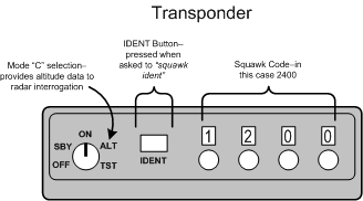
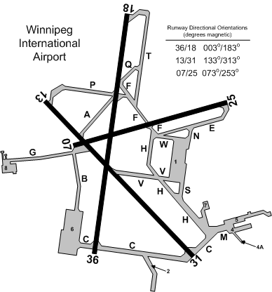
Transponders with Mode C (automatic altitude reporting capability) are always required in Class A, B, and C airspace as discussed above, but are also required in Class D and E airspace as specified in the Designated Airspace Handbook and as indicated on VFR navigation charts. Mode C, for example, is required in such Class D TCAs such as Winnipeg International and Halifax International, and the Class E airspace surrounding Regina and Moncton. More sweepingly, however, Mode C is required in all Class E airspace between 10000’ and 12500 ASL with any area with ATC radar coverage. While this does not yet appear on VHF navigation charts, this area includes much of the airspace in the provinces.12
Unless otherwise advised by ATC, transponder should be selected on Code 1200 for VFR flight at or below 12500’ ASL; above 12500’ ASL, Code 1400 should be selected.
Dedicated codes also exist for communication loss and flight emergencies; in the event of a communication failure, Code 7600 should be selected; in the event of an emergency, Code 7700 should be selected.
Fuel Requirements
Taking into account flying conditions, a VFR flight must have fuel sufficient to fly during the day to the intended place of landing, plus an additional 30 minutes at normal cruising speeds. For night flight, the fuel reserves must be extended to 45 minutes. In calculating fuel requirements, the pilot is required to make allowance for taxiing and foreseeable delays prior to takeoff, meteorological conditions, foreseeable air traffic routings and traffic delays, and, as is written in CAR 602.88(5)(e), “any other foreseeable conditions that could delay the landing of aircraft.”
It is illegal to refuel a private aircraft with the engine running, or while passengers are on board.13Note, however, that there are provisions for commercial aircraft operators to fuel with passengers provided specified safety guidelines are followed (see, for example, CAR 704.33 (1)).
Passenger Briefings
In accordance with CAR 602.89, the pilot must brief all passengers prior to takeoff with respect to the following:
- the location and means of operating emergency and normal exits, seat belts;
- the positioning and securing of seats, seat backs, and chair tables;
- the stowage of carry-on baggage;
- the location and means of operating oxygen equipment when required;
- the location and use of personal flotation devices when required;
- the location and use of first aid kits;
- the location and use of survival equipment when required;
- any prohibition against smoking.
Pilot Privilege
For the purpose of training, a private pilot can fly any aircraft provided no passengers are being carried and he/she is under direct supervision of an authorised person.
If a private pilot wishes to fly with passengers, he or she can only fly an aircraft category, class, or type that is endorsed on his licence.
To fly with passengers, a pilot must have flown at least five takeoffs and landings in aircraft of the same category and class within the preceding six months.
To fly with passengers at night, the required five takeoffs and landings must have been flown at night within the preceding six months.
The Minister of Transport has the authority to cancel or suspend your licensed privileges under two conditions: he has reasonable grounds to believe you have violated any provisions of the rules and regulations that govern flying, or he has reasonable grounds to believe you are incompetent or medically unfit to fly.
A pilot is required to desist from flying when he is aware of acquired physical disabilities that make him unable to pass his medical.
Alcohol
No person will fly while under the effect of a drug that compromises the safety of flight, while under the influence of alcohol, or within 8 hours of consuming an alcoholic beverage.
Anaesthetics
With spinal or general anaesthetics, a pilot should not fly until a doctor says it is safe to do so. With respect to local anaesthetics involving extensive procedures (such as the removal of several wisdom teeth), a pilot should not fly for 24 hours.
Wake Turbulence
Wake turbulence is caused by wing tip vortices that are produced by the air pressure differential above and below the wing.
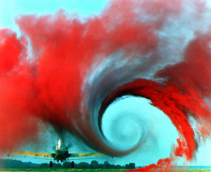
The vortex can produce structural loads as high as 10g. While the up gust/down gust has been estimated at 80 ft. per second (fps), most small aircraft are designed to withstand gusts of 30 fps. (Gusts near thunderstorms can exceed 45 fps.)
The strongest vortices are generated by heavy weight, clean configuration, at slow speeds. Accordingly, the worst is a heavy jet during touchdown and takeoff phases. Helicopters produce dangerously concentrated vortices.
It takes 2 minutes for the strength of vortices to dissipate (the smoother the air [non-turbulent], the slower the dissipation).
During touchdown, the generation of vortices does not stop until the jet’s nose-wheel touches down.
During takeoff, the vortices are generated as soon as the jet rotates.
Vortices tend to spread out at a speed of 5 KT. A 5 KT crosswind can therefore hold one of the vortices over the touchdown or takeoff area, or cause them to migrate to adjacent runways.
Wake Turbulence Regulations
In Canada, aircraft are classified with respect to wake turbulence as per the following:
|
Group |
Description |
|---|---|
|
Heavy |
All aircraft certified for a maximum takeoff weight of 300,000 lbs. or more. |
|
Medium |
Aircraft certified for a maximum takeoff weight of between 12,500 and 300,000 lbs. |
|
Light |
Aircraft certified for a takeoff weight up to 12,500 lbs. inclusive. |
Departures
If a departure occurs at an airport where the ATC tower unit does not have access to radar (a “non-radar departure”), controllers will apply a two-minute separation interval to any aircraft that takes off into the wake of a known heavy aircraft if
- the aircraft concerned commences the takeoff from the threshold of the same runway; or
- any aircraft departs from the threshold of a parallel runway located less than 2,500’ from the runway just used by a heavy aircraft.
Caution: ATC does not apply this two-minute spacing interval to light aircraft following a medium aircraft in the event of the above circumstances, but simply issues wake turbulence advisories—“CAUTION—WAKE TURBULENCE.”
Be aware (but you need not memorize) that a three-minute separation interval is applied by controllers in a non-radar environment to any aircraft that takes off following a heavy aircraft, or any light aircraft following a medium if
- the following aircraft begins its takeoff roll from an intersection or from a point further along the runway than the preceding aircraft; or
- the controller has reason to believe that the following aircraft will require more runway length for takeoff than the preceding aircraft.
In all cases, ATC tower controllers will advise affected pilots when the interval has been applied; for example,
Tower: “Negative, hold short for wake turbulence. Heavy Boeing 747, Rotating at 6000’,” or
Tower: “Taxi to position and hold for wake turbulence, Heavy DC10 Airborne at 2 miles.”
To facilitate occasions when the threat of wake turbulence is reduced—as may be the case with a steady crosswind—pilots may waiver the applicable time spacing interval
Wake Turbulence Rules of Thumb
On the Ground
- Before requesting clearance to cross a live runway, wait a few minutes if a large aircraft has just landed or taken-off.
- When holding near a runway, anticipate wake turbulence.
Takeoff
- When cleared to takeoff after a departing large aircraft, plan to become airborne prior to that aircraft’s rotation path, staying above or turning away from its departure path.
- When cleared to take off after a landing large aircraft, plan to become airborne after its nose-down point.
In flight
- Avoid flight below and behind large aircraft.
Landing
- When cleared to land behind a departing large aircraft, plan to touchdown before the rotation point.
- When cleared to land behind a landing large aircraft, remain above its flight path, and plan to touch-down after its nose-down point.
- Plan approach to avoid vortices generated by aircraft operating on parallel or cross runways.
- It is crucial for safety that all pilots realize that, while ATC is required to issue wake-turbulence cautions, avoidance is solely the pilot’s responsibility.
Jet Blast Hazard
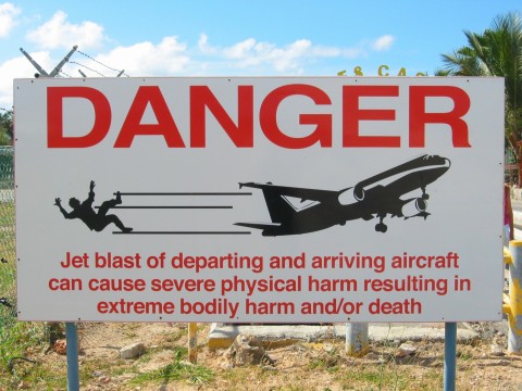
Extreme caution must be used when manoeuvring on the ground at airports where jet operations occur.
As a rule, never taxi behind a jet aircraft unless you can be assured that the engines are not operating; if operating, the following are published distances that can be used for reference:
|
Jet Blast Hazard |
||
|---|---|---|
|
CATEGORY |
IDLE DANGER |
TAKEOFF DANGER |
|
Heavy |
600’ |
1600’ |
|
Medium |
450’ |
1200’ |
|
Light |
200’ |
500’ |
A taxiing jet or turbo-prop aircraft can produce winds in excess of 60 KTS.
The pilot has sole responsibility for jet blast avoidance.
Seat Requirements
The Pilot-in-command must direct all persons on board to fasten safety belts when the aircraft is moving on the surface, during takeoffs and landings, and at any other time deemed necessary by the Pilot-in-command.14
In the case of infants less than 2 years of age, the infant must be securely held in the arms of adult when seat belts are required to be worn.
The Pilot-in-command or a qualified pilot must remain in his seat belt during flight time.15
Oxygen
The following apply primarily to unpressurized aircraft, but are applicable to the cabin-pressure altitude of pressurized aircraft.
A pilot cannot fly an aircraft for more than 30 minutes above 10000’, or above 13000’ for any length of time unless he or she is wearing and using oxygen equipment.16
When flying for more than 30 minutes above 10000’ sufficient oxygen and equipment must be available for 10% of the passengers (not less than one passenger) for the entire period exceeding 30 minutes.
When flying above 13000’ there must be available oxygen and equipment for each passenger sufficient for the entire period above 13000’.
Above 13000’ all passengers must wear and use oxygen equipment.
Documents on Board Aircraft
It is required that the following be carried on board aircraft: flight crew licences, including Medical Certificate and radio licence; Certificate of Registration and Certificate of Airworthiness (including annual inspection report); aircraft and pilot radio licences; aircraft Journey Log (when it is planned that an aircraft will land and shut-down at an airport other than the airport of departure).
The Pilot Operating Handbook, interception orders , and aircraft weight and balance report must also be on board.
The Pilot Operating Handbook must be accessible to the pilot at his or her station.
Aircraft Equipment Requirements
Operational and Emergency Equipment Requirements
CAR 605.14 Power-driven Aircraft - Day VFR
No person shall conduct a take-off in a power-driven aircraft for the purpose of day VFR flight unless it is equipped with
-
- where the aircraft is operated in uncontrolled airspace, an altimeter;
- where the aircraft is operated in controlled airspace, a sensitive altimeter adjustable for barometric pressure;
- an airspeed indicator;
- a magnetic compass or a magnetic direction indicator that operates independently of the aircraft electrical generating system;
- a tachometer for each engine and for each propeller or rotor that has limiting speeds established by the manufacturer;
- an oil pressure indicator for each engine employing an oil pressure system;
- a coolant temperature indicator for each liquid-cooled engine;
- an oil temperature indicator for each air-cooled engine having a separate oil system;
- a manifold pressure gauge for each
- reciprocating engine equipped with a variable-pitch propeller,
- reciprocating engine used to power a helicopter,
- supercharged engine, and
- turbocharged engine;
- a means for the flight crew, when seated at the flight controls to determine
- the fuel quantity in each main fuel tank, and
- if the aircraft employs retractable landing gear, the position of the landing gear;
- subject to Subsections 601.08(2)17 and 601.09(2),18 a radio-communication system adequate to permit two-way communication on the appropriate frequency when the aircraft is operated within
- Class B, Class C or Class D airspace,
- an MF area, unless the aircraft is operated pursuant to Subsection 602.97(3),19 or
- the ADIZ;
- where the aircraft is operated under Subpart 4 of this Part,20 or under Subpart 3, 4, 5 of Part VII,21 radio-communication equipment adequate to permit two-way communication on the appropriate frequency;
- where the aircraft is operated in Class B airspace, radio navigation equipment that will enable it to be operated in accordance with a flight plan; and
- where the aircraft is operated under Subpart 4 of this Part or under Subpart 5 of Part VII, radio navigation equipment that is adequate to receive radio signals from a transmitting facility.
CAR 605.15 Power-driven Aircraft - VFR OTT
- No person shall conduct a take-off in a power-driven aircraft for the purpose of VFR OTT flight unless it is equipped with
- the equipment referred to in paragraphs 605.14(c) to (j);
- a sensitive altimeter adjustable for barometric pressure;
- a means of preventing malfunction caused by icing for each airspeed indicating system;
- a gyroscopic direction indicator or a stabilized magnetic direction indicator;
- an attitude indicator;
- subject to Subsection (2), a turn and slip indicator or turn co-ordinator;
- where the aircraft is to be operated within the Northern Domestic Airspace, a means of establishing direction that is not dependent on a magnetic source;
- radio communication equipment adequate to permit two-way communication on the appropriate frequency; and
- radio navigation equipment adequate to permit the aircraft to be navigated safely.
- Where the aircraft is equipped with a standby attitude indicator that is usable through flight attitudes of 360 degrees of pitch and roll for an aeroplane, or ± 80 degrees of pitch and ± 120 degrees of roll for a helicopter, the aircraft may be equipped with a slip-skid indicator in lieu of a turn and slip indicator or turn co-ordinator.
CAR 605.16 Power-driven Aircraft - Night VFR
NOTE: Night begins when the centre of the sun is more than 6° below the horizon (generally, not less than 25 minutes after sunset or before sunrise).
- No person shall conduct a take-off in a power-driven aircraft for the purpose of night VFR flight, unless it is equipped with
- the equipment referred to in paragraphs 605.14(c) to (n);
- a sensitive altimeter adjustable for barometric pressure;
- subject to Subsection (2), a turn and slip indicator or turn co-ordinator;
- an adequate source of electrical energy for all of the electrical and radio equipment;
- in respect of every set of fuses of a particular rating that is installed on the aircraft and accessible to the pilot-in-command during flight, a number of spare fuses that is equal to at least 50 per cent of the total number of installed fuses of that rating;
- where the aircraft is operated so that an aerodrome is not visible from the aircraft, a stabilised magnetic direction indicator or a gyroscopic direction indicator;
- where the aircraft is to be operated within the Northern Domestic Airspace, a means of establishing direction that is not dependent on a magnetic source;
- where the aircraft is an airship operated within controlled airspace, radar reflectors attached in such a manner as to be capable of a 360° reflection;
- a means of illumination for all of the instruments used to operate the aircraft;
- when carrying passengers, a landing light; and
- position and anti-collision lights that conform to the Aircraft Equipment and Maintenance Standards22
Additional Equipment Requirements
Operational and Emergency Equipment Requirements for Aeroplanes are set out in Canadian Aviation Regulation 602.60 through 602.63.
All aircraft must have a checklist and/or placards to facilitate operation in accordance with the manufacturer’s requirements.
The checklist and/or placards must provide for proper operation in normal, abnormal, and emergency flight conditions, and must specifically include pre-start checks, pre-takeoff checks, post-takeoff checks, pre-landing checks, and emergency procedures checks
Emergency checks must specify emergency operation of hydraulic, electrical, and mechanical systems, emergency operation of instruments and controls, engine inoperative procedures, and any other procedures necessary for aviation safety. All checks and emergency procedures must be performed and followed by the flight crew.
When operating VFR OTT, night VFR, or IFR, the aircraft must have all necessary charts and publications for the route flown, including any probable diversionary route; the charts and publications must be current.
All aircraft must have accessible in the cockpit a suitable, non-toxic, and readily available fire extinguisher.
Each crewmember (excluding passengers) must have access to a functioning timepiece and, when operating at night, a functioning flashlight.
All aircraft must have a first aid kit.
Except when undertaking flight within 25 nautical miles of the airport of departure where continuous radio contact with base station is possible for the duration of flight, no person can operate an aircraft without specified survival equipment.23 The survival equipment must be adequate for the survival on the ground of each person on board the aircraft with due consideration for geographic area, seasonal and climatic variations; all survival equipment must provide a means for the following:
- starting a fire;
- providing shelter;
- providing or purifying water; and
- visually signalling distress.
With respect to flight over water, a single-engine aircraft operating beyond gliding distance from shore must be equipped with one lifejacket for each individual on board.24 The lifejackets must be stored on board in a fashion so as to be easily accessible to person for whom it is intended when that person is seated.
If a single-engine aircraft is operated over water beyond 100 nautical miles from a suitable emergency landing site, or if the aircraft is operated over water beyond a distance at which the same landing site cannot be reached within 30 minutes at the cruising speed specified in the flight plan or flight itinerary, the aircraft must be equipped with life raft sufficient in total rated capacity to accommodate all persons on board.25
With respect to a multi-engine aircraft unable to maintain flight with any engine failed, the above 100 NM or 30 minute above rule applies. In the case of multi-engine aircraft capable of maintaining flight with any engine failed, the distance is extended to 200 NM and the time is extended to 60 minutes.
Aircraft Icing
It is illegal to conduct or attempt to conduct a takeoff in an aircraft that has frost, ice, or snow adhering to any of its critical surfaces (i.e., wings, control surfaces, rotors, propellers, horizontal stabilizers, vertical stabilizers, or any other stabilizing surface of the aircraft).26
Minimum Altitude
Over a built-up area (City, Town, Village, or assembly of persons), an aircraft must be flown at a sufficient altitude to allow a safe emergency landing, and at no time should that be below 1000’ above the highest obstacle within a 2000’ radius (except for the purposes of landing or taking-off).27
Over non-populous areas, an aircraft must be flown at an altitude that does not present a hazard to person or property, and at no time less than 500’ distance from any person, vessel, vehicle or structure (except for the purposes of landing or taking-off).28
Rules of the Air
Aircraft cannot fly less than 2000’ above an aerodrome, except for the purpose of landing or taking off.29
Prior to beginning a flight, the pilot-in-command must be familiar with all available information appropriate to the intended flight.Be30
Beginning a flight, the pilot-in-command must be familiar with all available weather information appropriate to the intended flight.31
No person shall create a hazard to persons or property by dropping an object from the aircraft during flight.32
No person shall operate an aircraft in proximity to another aircraft that may create a risk of collision.33
An aircraft engine shall not be started unless a competent person occupies the pilot seat, or the aircraft is prevented from moving forward. No person shall leave an aircraft engine running unless a competent person is at the controls or, where no person is on board, precautions have been made to prevent the aircraft from moving forward and the aircraft is not unattended.34
A pilot must land when instructed to do so by an air traffic control unit, peace officer, customs or immigration officer, officer of the Armed Forces, or person authorized by the Minister.
A pilot must produce his licence and related documents upon demand by a peace officer, customs or immigration officer, officer of the Armed Forces, or person authorized by the Minister.
All crewmembers shall, during flight time, obey the orders, instruction, and commands of the Pilot-in-command.35
When two aircraft are approaching head-on, each shall alter course to the right.36
An aircraft overtaking another shall pass on the right.
When two aircraft are converging, the one on the right has the right of way, but must take whatever action necessary to avoid collision.
Based on manoeuvrability, aircraft have priority of right of way in the following order: Fixed or free balloons, gliders, airships, and fixed or rotary wing aeroplanes.
A distressed aircraft has landing priority.
An aircraft towing another has priority over other aircraft.
If two aircraft are approaching for landing, the higher must give way to the lower.
An aircraft on the ground or in water must give way to an aircraft about to land.
Additonal Readings: The 10 Most-contravened Canadian Aviation Regulations.
References
1 When you land at an airport with a control tower or a Flight Service Station (FSS), the landing is automatically reported to the operator. When you land at an airport where no such representative exists, the pilot must sign a “registry”—usually posted in the main terminal or office. This is required if you should land at Chilliwack, for example. The registry records the aircraft and pilot information, as well as the arrival and departure time of the aircraft, as well as its proposed destination. In the event that an aircraft is missing, the registries will be used during the search response, so it is important to use them properly.
3 Questions related to the definitions of manoeuvring area and apron commonly appear on Transport Canada examinations.
4 “Unicom” is derived from “universal communication,” and these frequencies are listed in the Canada Flight Supplement.
5 Langley Airport becomes a MFA airport when the tower closes.
6 The ATIS frequencies are published in the Canada Flight Supplement.
7 TAFs are described the following links: TAFs
8 Weather information is discussed in full at the following link: Weather Information.
10 ESCAT rules came into effect for the first time following the tragic events of September 11th.
11 The exception is multi-engine, turbo-jet aeroplanes operating IFR south of 66° 30’ North Latitude.
12 See the Aeronautical Information Manual (AIM), RAC 1.10.2. The AIP is available in PDF format on Transport Canada’s website.
17 CAR 601.08 (2) states as follows: “The pilot-in-command of a VFR aircraft that is not equipped with radio-communication equipment capable of two-way communication with the appropriate air traffic control unit may, during daylight in VMC, enter Class C airspace if the pilot-in-command receives authorization to enter from the appropriate air traffic control unit before entering the airspace.”
18 CAR 601.09 (2) provides the same text as CAR 601.09 (2), except is applicable to Class D airspace.
19 This CAR provides provision for NORDO (no radio) aircraft to operate in a MFA when the designated ground station is operating and there is prior co-ordination.
20 Subpart 4 governs “Private Passenger Operations” for turbine aircraft—corporate aircraft, etc.
21 Part VII denotes commercial operations—specifically, Air Taxi (Subpart 3), Commuter (Subpart 4), and Airline (Subpart 5) operations.
22 The specifications that govern position and equipment lights.