.jpg)


THE PUBLISHED INSTRUMENT APPROACH
Instrument approaches are, of course, the centre of the Instrument Rating. While they are beyond the scope of this Handbook, the opportunity will arise when you are provided with a published approach procedure, along with the expectation that you fly the aircraft under the hood down to the vicinity of the runway threshold—in the case of some published procedures, as low as 200’. This section reviews how to interpret the final phase of a published approach procedure that leads to the runway threshold—what is refer to as the final approach course.
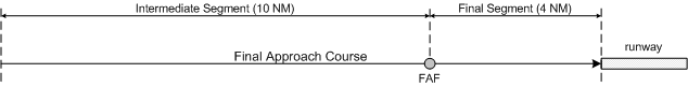
You should know, firstly, that the final approach course is a straight-line track that is normally aligned with the runway centreline, and that it normally extends approximately 15 NM back in the direction from which an approach is made.
The final approach course is defined by a navigation aid—often an NDB located along the final approach course, but sometimes an ILS localizer is used, sometimes a VOR radial is used, and sometimes a GPS waypoint.
Located on the final approach course is the final approach fix (FAF). The FAF is usually located about four miles from the runway threshold. The portion of the final approach course that lies between the FAF and the threshold is referred to as the final segment, while the portion of the final approach course extending from the FAF outward to not more than 10 NM is the intermediate segment. On occasion a course change is required at the FAF, but this is generally rare (see the published approach procedures for Nanaimo Airport).
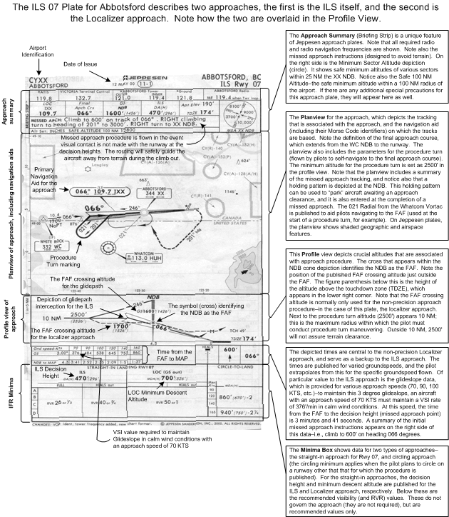
There are two types of published approaches—what are referred to as non-precision approaches, and precision approaches. Precision approaches are approach procedures on which radio navigation is based on an Instrument Landing System (ILS). Non-precision approaches are based on NDB, VOR, GPS, or Localizer (ILS display without glideslope). A precision approach is precise in that the aircraft approaches the runway threshold in the landing attitude and configuration—that is, the aircraft tracks from the FAF to runway threshold in a descending attitude, and the gear and flaps are configured for landing. The vertical placement of the aircraft is based on radio instrument indications of the glideslope portion of the ILS, while the centreline placement is provided by the localizer portion of the ILS. Based on a published ILS approach procedure, it is common for aircraft to have the authority to descend as low as 200’ above the runway surface without visual reference to the ground. In contrast , a non-precision approach procedure is based on track information only, and there is no vertical guidance (as is the case with glideslope of an ILS). With a non-precision approach, the pilot simply maintains the final approach track towards the threshold of the runway, and descends to increasingly lower altitudes as the runway is approached, as per the published procedure.

The intermediate segment (outside the FAF) and the final segment (inside the FAF) each have a published altitude to which the pilot can safely descend. In the case of a precision ILS approach, the pilot will typically hold a selected altitude after intercepting the final approach course during the intermediate segment, and begin a constant, stabilized descent when the glidepath is intercepted. For non-precision approaches, however, the pilot can “step down” to the minimum published altitude for the segment.
The minimum altitude for the intermediate segment is referred to as the FAF crossing altitude. In the case of a non-precision approach, the minimum altitude is the minimum descent altitude or MDA. Descent below the MDA is only permitted when visual reference exists with the runway. In the case of a precision approach, the equivalent minimum altitude is referred to as decision height (DH); it is prohibited to continue an approach without visual reference to the runway below DH.
The missed approach—the equivalent to the overshoot—is conducted on an instrument approach if visual reference with the runway is not established. In the case of a precision ILS approach, the missed approach is initiated when the DH is indicated on the altimeter. In the case of non-precision approach, the missed approach point (MAP) is defined by either time or distance (DME or GPS).
GPS Approaches
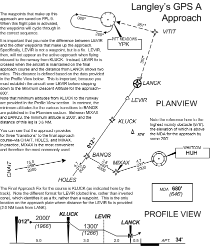
GPS approaches are classified as a non-precision approach (there is no glideslope tracking), but they vary from other non-precision approaches in that the GPS automatically cycles through the sequence of waypoints that make up “the approach.” This compares with other traditional approaches where only one ground-station transmitter is used for the entire approach. Generally, the approach is loaded into the GPS and the pilot begins to navigate to the final approach course via radar vectors or via one the published transitions. In the case of Langley’s GPS A approach, there are three transitions that lead to the final approach course—CHAIT, HOLES, and MIXAX.1 As can be seen on the depiction located below (extracted from the published procedure for Langley Airport). The Langley approach varies from the other instrument approaches contained in this Handbook in that it is a circling approach (hence, you see the letter “A” for “alpha” instead of the runway number. The reasons for this are rather technical, but the end result is that Langley’s approach is defined as a “circling approach” rather than a “straight-in” approach. This doesn’t mean you cannot proceed with a straight-in landing on Runway 01; it simply means the approach does not meet the stringent criteria to qualify as a published straight-in approach. For the Langley approach, the FAF is KLUCK, and after crossing KLUCK the aircraft (established on the final approach course) can descend down to 1300’. The MDA is 680’ (when Langley Tower is operational), but a safe descent to this altitude can only be initiated when the pilot determines that the aircraft is located inside LEVIR. Note that LEVIR is not a waypoint, but is a fix, based on the published distance form LANCK (the missed approach point)—to descend to the MDA, the aircraft must be at or within 2 NM of LANCK. This approach is not timed; if the runway is not visible when the aircraft arrives at LANCK, a missed approach is initiated. If the runway becomes visible, and Runway 01 is active, the pilot simply transitions to the final approach descent, usually with reference to the PAPI. If Runway 19 is active, the pilot levels off at the MDA and begins a circling manoeuvre to position the aircraft on the final approach for Runway 19. The rules for circling are rather stringent, and you want to get good at flying this manoeuvre (in actual IFR conditions, the aircraft is manoeuvred exceptionally close to the ground in poor visibility conditions). The aircraft should be maintained exactly at the MDA, and in the case of the Cherokee, it must be kept within 1.3 NM of the nearest runway surface. A descent for landings must not be initiated unless safety with respect to obstacle clearance is assured. Avoid the habits of flying a square pattern—instead, strive to keep the aircraft in a slightly banked attitude with the inside wing lowered.
During simulated GPS practise, you will be manoeuvring in close proximity to the Langley airport, well below normal circuit altitude, so it will be required that you properly comply with any restrictions or cautions provided by the tower. Here are some examples of the radio communications during a GPS approach at Langley Airport:
|
Pilot: |
|
“Langley Tower, this is Piper Cherokee GABC on the simulated GPS approach, two miles back from KLUCK at 2000’. We have information CHARLIE.” |
|
Controller: |
|
“ABC, the simulated GPS A is approved. Maintain VFR at all times. Report KLUCK inbound with your intentions.” |
|
Pilot: |
|
“ABC is KLUCK Inbound, requesting to circle west2 of the airport” or “requesting the straight-in approach.” |
|
Controller: |
|
“ABC, roger, report LEVIR . . .” or “. . report LANK” or “. . report 2 miles back from the airport.” |
References
1 After the flight plan containing the approach waypoints (in proper sequence) is loaded (it is usually stored on FPL 9), the normal procedure is to track directly to one of the transition waypoints (CHAIT, HOLES, or MIXAX), and from there to BANQS and the final approach course. In the case of a vectored approach, KLUCK is brought up on the GPS as the active waypoint (in OBS Mode with the 012° track selected); before crossing KLUCK inbound, the GPS must be placed in Leg Mode so that it automatically cycles to the next waypoint in the flight plan—in this case, LANCK. (Note that LEVIR is not a waypoint, but is a fix defined as 2 NM back from LANCK.)
2 Circling is not normally done east of the airport, owing to the location of the hospital.
G